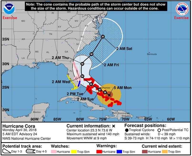
At 1100 AM EDT, the center of Hurricane Cora was located near latitude 23.3 North, longitude 73.6 West. Hurricane Cora is moving toward the west-northwest near 9 mph (15 km/h). Maximum sustained winds are near 140 mph (220 km/h) with higher gusts. Hurricane Cora is a category 4 hurricane on the Saffir-Simpson Hurricane Wind Scale. Little change in strength is forecast during the next 48 hours. Hurricane-force winds extend outward up to 60 miles (95 km) from the center and tropical storm-force winds extend outward up to 175 miles (280 km). The estimated minimum central pressure is 938 mb (27.70 inches).
Hurricane Cora (Category 4) expected to move through the Bahamas as an extremely dangerous major hurricane. Hurricane and storm surge watches in effect for much of the Florida east coast.
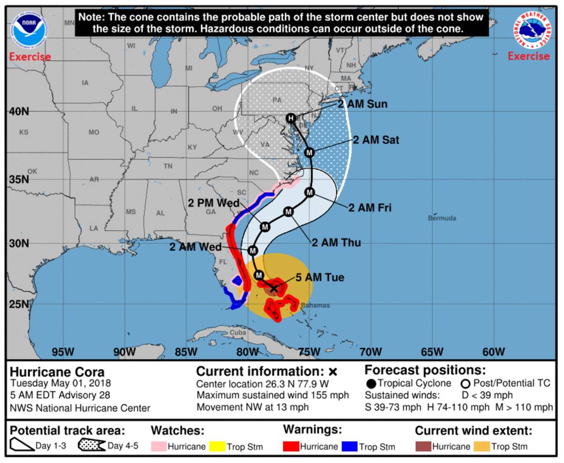
NWS National Hurricane Center Miami FL AL872018 500 AM EDT Tue May 01 2018
Tropical Storm Warnings and Hurricane Watches issued in the Carolinas.
Hurricane Cora remains an extremely intense hurricane with a 10 nm wide eye as seen from both the Miami WSR–88D radar and the GOES-R infrared satellite imagery. Measurements from the NOAA P–3 aircraft indicate that the system continues to gradually strengthen and a blend of adjusted flight-level winds and SFMR gives an initial intensity of 135 kt.
With the well-defined eye, Cora’s initial movement is confidently determined to be northwest at 11 kt. Cora is rounding the western periphery of the deep-layer subtropical ridge and should recurve toward the north-northeast beginning around 36 hr, moving parallel to the southeastern U.S. coastline. After that, the uncertainty increases substantially, as the global model track diverge, although the 00Z guidance is still insistent on a turn back toward the north and possibly north-northwest between days 3 to 5. The new NHC track forecast is based upon a blend of the 00Z GFS and ECMWF models and is similar to the previous advisory.
While Cora’s intensity has continued to climb overnight, conditions are not expected to be as conducive with the vertical shear expected to increase today. However, with the ridge rebuilding and pushing Cora back toward the north-northeast, the shear never reaches extremely high values. The intensity forecast shows a gradual weakening for the next 4 days with shear slowly increasing and moisture/SSTs decreasing. The intensity forecast is also complicated by the possibility of eyewall replacement cycles and weakening induced by land. For example, if more of Cora’s circulation moves over Florida that is currently expected, there would likely be more weakening than shown in the NHC forecast. The intensity forecast is based upon the IVCN intensity model consensus and is nearly the same as the previous NHC prediction.
KEY MESSAGES:
Cora is an extremely dangerous hurricane that is affecting the northern Bahamas dangerous winds, torrential rainfall, and life-threatening storm surge.
While the official track forecast shows Cora’s center remaining just offshore of the east coast of Florida, any westward deviation of Cora’s eye could bring the strongest winds and highest storm surge to the Florida east coast. Hurricane and Storm Surge Warnings therefore remain in place for most of the east coast of Florida and the southern Georgia coast.
The threat of northern Georgia coast, South Carolina, and southwestern North Carolina coast experiencing the dangerous core of Hurricane Cora has decreased somewhat. Despite this, some impacts from Cora are likely in these areas, and Tropical Storm Warnings and Storm Surge Watches continue along with a Hurricane Watch. Any significant deviation of the forecast track toward the west would increase the magnitude of the impacts in these areas.
North Carolina and all of the mid-Atlantic states are at risk for direct impacts from Cora from Wednesday night through Sunday.
Residents in those areas should have their hurricane plan in place and follow any advice given by local officials.
As of 5:00 AM, Hurricane Cora is a powerful Category 4 Hurricane located South of Grand Bahama, with winds of 155 MPH. Hurricane-force winds extend outward up to 60 miles from the center and tropical-storm-force winds extend outward up to 205 miles.
Locally, the non-tropical low pressure system sitting just off the Maryland shore has stalled and is forecast to continue bringing heavy rain over the next 24 hours. Approximately 5 inches of rain has already fallen, with some localized areas receiving up to 7 inches.
Hurricane Cora is an extremely dangerous storm, and there is increasing forecast certainty that Northern Virginia will receive significant storm impacts in the next five to seven days. All EOC staff and PWC essential personnel should begin to prepare their residences and families for the effects of a category 2+ hurricane. Emergency Management is briefing the County’s executive team later this morning; a decision on activation of the EOC will be communicated before close of business today.
The Prince William County EOC increased status to full activation as of this morning at 0700.
As of 0500, May 02, 2018, the National Hurricane Center (NHC) has issued a Hurricane Watch from the North Carolina/Virginia border to Cape Henlopen Delaware.
A hurricane watch means that hurricane conditions are possible within the watch area.
A watch is typically issued 48 hours before the anticipated first occurrence of tropical-storm-force winds and conditions that make outside preparations difficult or dangerous.
Cora is forecast to remain at or near major hurricane intensity through landfall late Friday or early Saturday in the Mid-Atlantic Region, and residents from northern North Carolina through the Delmarva Peninsula (See Image Below), should prepare for the possibility of life-threatening wind, storm surge, and rainfall hazards from Cora.
Rain continues to fall in the Mid-Atlantic region at an average rate of 0.18 inches per hour. Radar data suggests that the storm system has deposited approximately 6.0–9.0 inches of rain throughout the National Capital Region and Delmarva Peninsula within the past 72 hours.
Hurricane Cora is an extremely dangerous storm and there is increasing forecast certainty that Northern Virginia will receive significant storm impacts in the next three to four days. All EOC staff and PWC essential personnel should finalize preparations for their residences and families in the next 12 hours.
The following roads/intersections are closed due to high water:
Water has been reported encroaching on approximately 25 homes along Lake Jackson; numerous outbuildings along the Lake are already inundated. Two boats broke free from their moorings and are lodged against the catwalk at the Lake Jackson Dam.
The center of Hurricane Cora is 20 Miles ENE of Quantico, over Charles County, MD, with sustained winds of 110 MPH. Catastrophic loss of power and communications is expected in the next few hours, and tropical storm-force winds are expected to continue through most of Sunday 5/6. Catastrophic storm surge flooding of 12+ feet is occurring along the Potomac river Countywide and throughout the entire region. Sustained winds of 85–100 MPH are expected for the next 6–12 hours. All personnel should shelter-in-place inside the most interior room on the lowest level of the structure until further notice.
8:00 AM ET Sunday, May 6, 2018 – Post Landfall
At 8:00 AM ET, Tropical Storm Cora was near Carlisle, Pennsylvania (40.2°N, 77.1°W) with sustained wind speeds of 60 mph. The Potomac River rises to unprecedented levels due to the hurricane’s rain and the previous non-tropical low-pressure storm system.
3:00 PM ET Sunday, May 7, 2018 – Post Landfall
The PWC EOC receives a report from a United States Coast Guard overflight relayed by the Virginia State EOC: All structures in Featherstone, Dawson Beach, and along Neabsco, Powells, and Quantico Creeks are heavily damaged or destroyed. In Eastern PWC, US–1 is completely washed out at Marumsco Creek, Featherstone Road is under water just past Blackburn Road, and the US–1 Bridge at Neabsco Creek is under water.
PWC Department of Fire and Rescue and Police personnel have resumed answering critical calls for service, but are unable to access many areas due to standing water over roadways. The PSCC and Citizen Information Line are overwhelmed with calls reporting flooding inside structures and inquires about the nearest shelter or availability of food and water.
The PWCSA reports that it has lost communication with many of its lift stations and booster stations on the East side of PWC and needs assistance with high water vehicles or boats on Monday to assess water system conditions. Contact is made with both Dominion Energy and NOVEC, who report that nearly 90 % of their customer base in PWC is without power and it remains unsafe for crews to begin assessment and restoration efforts until Monday morning.
What if:
We would need help. The decision points include the status of the Fed (not covered) and the local destruction beyond the DC Metroplex. I would be reaching out to Howard (DEC) and asking for state support at a minimum and coordinating with the VAC for an arrival site and just in time training space. One thing we need in this regard is some just in time training. I know Meola and myself wrote up a FAQ, so I am making a note to dig that out.
I would expect the repeaters would be in sad shape, so VHF simplex.
HF would be a mixed bag, but both OVH and WWI, as well as others could provide backup antennas. I would still go with the primary mode of someone off site providing HF.
We have our work cut out for us staffing shelters, hospitals, EOC(s), and other critical locations (PD/Fire)
Getting around could mean that the EC at the EOC is not an AEC, and could be an available operator working as my deputy. (And I would be tasking others with tactical task while I am dealing with strategic ones.)
Ponder alternate routes for getting from here to there (and likely APRS).